Enviar búsqueda
Cargar
the basic elements of a map
•
Descargar como PPTX, PDF
•
2 recomendaciones
•
5,554 vistas
J
jvoss8
Seguir
Educación
Tecnología
Arte y fotografía
Denunciar
Compartir
Denunciar
Compartir
1 de 8
Descargar ahora
Recomendados
Day 2 of GIS training at IOE,Pulchowk.
Introduction to MAPS,Coordinate System and Projection System
NAXA-Developers
Map Elements
Map Elements
Dan Klumper
Map Design and Symbology in GIS Environment
Kaium Chowdhury
GIS and its application on Health, New advances
Gis
Gis
Swornim Bajracharya
Digital cartography presentation; workshop wiki is at http://pwoessner.wikispaces.com/Digital+Cartography
Digital Cartography
Digital Cartography
Patrick Woessner
Gis Applications Presentation
Idua Olunwa
not mine, downloaded from esri.com. I think it is an awesome presentation. enjoy it.
History of GIS
History of GIS
Walter Simonazzi
How Geographic Information System use in Disaster Management.
Fundamentals of GIS and Database Management for Disaster Management
Syadur Rahaman
Cartographic map design process and principles
Cartographic map design
Khilaraj Chouhan
Map design in GIS
Map design in GIS
Map design in GIS
Hans van der Kwast
oceanic crust
Gis functions
Gis functions
Shah Naseer
Topics: 1. What is Topology 2. Why Topology is important 3. Topological Errors 4. Components of Topology 5. Topology Rules
GIS - Topology
GIS - Topology
Malla Reddy University
Presentation delivered at DIALOG Design in Vancouver on May 28th, 2015.
GIS for Urban Planning and Design
Anthony Smith
For a new better version of this tutorial see my Google Slides with embedded videos. https://docs.google.com/presentation/d/1MftEOT3uvYpCVwUaLMhsesm5Que-Kr7GQRV4pKZ2SNQ/edit?usp=sharing This is a 2016 tutorial on how to do watershed delineation using ArcMap 10. It is an open education resource. Please let me know if you find it useful or see something that could be improved. Feel free to use it for teaching Geographic Information Science.
Watershed Delineation Using ArcMap
Arthur Green
This is about GIS. Details About Gis.
Gis
Gis
Sumeet Pattanaik
Topics: 1. What is Spatial Analysis 2. Types of Spatial Analysis 3. Spatial Modelling
Geo-spatial Analysis and Modelling
Malla Reddy University
Essential for the primary learners of Geographical Information System (GIS)
Introduction to gis
Introduction to gis
Habibur Rahman
gis
gis
yaesh
ArcMap is ArcGIS’s desktop application for all map-based tasks, like data and map analysis, editing and production of maps. In ArcMap, a user can display data, make selections, analyse data, manipulate data, create data, assign symbols and produce maps. ArcMap also serves as gateway to a number of software extensions that perform specific tasks and analyses (extensions will be discussed later in the course).
Introduction to-arc map
Ashok Peddi
What is GIS Principle of GIS Function of GIS Components of GIS Type of GIS Advantages of GIS Applications of GIS Organisation of GIS Data structure GIS GIS is a computer system capable of assembling, storing, manipulating, and displaying geographically referenced information, i.e. data identified according to their location. A GIS is an organised collection of computer hardware, software, geographic data , and personnel to efficiently capture , store, update, manipulate, analyze and display all forms of geographically referenced information.
GEOGRAPHICAL INFORMATION SYSTEM (GIS)
MAHENDRA PRATAP SWAIN
An introduction to geographic information systems (gis) m goulbourne 2007
Michelle Goulbourne @ DiaMind Health
The basic intention of this presentation is to help the beginners in GIS to understand what GIS is? It is a simple presentation about GIS, i mean an introductory one. Hope anyone finds it useful.
Getting started with GIS
Esri India
CARTOGRAPHY
Cartography lec #4
Cartography lec #4
Nazir Ahmed
Geographical information systems (GIS)
Geographic query and analysis
Mohsin Siddique
Gis based information
Cartographic_Design.ppt
ThomasHundasa1
GIS Training Module, Location Based Services, Introduction to GIS
A Journey to the World of GIS
Nishant Sinha
Meteorology is a discipline concerned with observational earth sciences and theoretical physics. It has the task of providing an accurate knowledge of the state of the atmosphere. Before the advent of weather satellites the weathermen had been severely handicapped by having only a very limited knowledge of the state of the atmosphere at any given time. Meteorological satellites have to a large extent has enabled to overcome this deficiency.
Meteorological Satellites
Manoj Barman
September 2012 GIS ToT Webinar
GIS and Mapping Software Introduction
MEASURE Evaluation
This presentation was provided by William Mattingly of the Smithsonian Institution, during the fourth segment of the NISO training series "AI & Prompt Design." Session Four: Structured Data and Assistants, was held on April 25, 2024.
Mattingly "AI & Prompt Design: Structured Data, Assistants, & RAG"
National Information Standards Organization (NISO)
Discover the Kisan Call Centre: Your Gateway to Agricultural Assistance KISAN CALL CENTRE In order to harness the potential of ICT in Agriculture, Ministry of Agriculture & Farmers Welfare launched the scheme “Kisan Call Centres” (KCCs) on January 21, 2004. Main aim of the scheme is to answer farmers’ queries on a telephone call in their own language. These call centres are working in 21 different locations in the country covering all the States and UTs. A countrywide common eleven digit Toll Free Number 1800-180-1551 has been allotted for Kisan Call Centre. This number is accessible through mobile phones and landlines of all telecom networks including private service providers. Replies to the farmers’ queries are given in 22 local languages. Kisan Call Centre services are available from 6.00 AM to 10.00 PM on all seven days of the week at each KCC location. Kisan Call Centre agents known as Farm Tele Advisors (FTAs), who are graduate or above (i.e. PG or Doctorate) in Agriculture or allied sectors (Horticulture, Animal Husbandry, Fisheries, Poultry, Bee-Keeping, Sericulture, Aquaculture, Agricultural Engineering, Agricultural Marketing, Bio-Technology, Home Science, etc.) and possess excellent communication skills in respective local language. Queries which cannot be answered by FTAs are transferred to higher level experts. These experts are Subject Matter Specialists (SMSs) of State Departments of Agriculture (SDAs), ICAR Institutes, KVKs and State Agricultural Universities (SAUs). A Kisan Knowledge Management System (KKMS) has been developed to capture all the details of the caller and sending gist of answer given through SMS. KKMS has its independent website : http://dackkms.gov.in. The KCC, FTAs working at various KCC locations throughout the country have access to this website through their specific IDs and password provided to them. Welcome to the Kisan Call Centre - your one-stop destination for agricultural assistance and support. With dedicated team of experts and cutting-edge technology, we're here to revolutionize the way farmers access information and guidance. In this powerpoint, we delve into the world of the Kisan Call Centre, exploring how it functions, the services it offers, and the impact it has on farmers across the nation. From real-time advisory services to multilingual support, we'll uncover the key features that make the Kisan Call Centre an indispensable resource for farmers of all backgrounds. Join us as we showcase the achievements of the Kisan Call Centre, from its enhanced farmer outreach to its empowerment of women farmers. Discover how our feedback mechanism ensures continuous improvement, and learn about our collaborations with agricultural institutions to provide accurate and reliable information. Whether you're a seasoned farmer or just starting out, the Kisan Call Centre is here to support you every step of the way. Subscribe now to stay updated on the latest agricultural insights
Kisan Call Centre - To harness potential of ICT in Agriculture by answer farm...
Krashi Coaching
Más contenido relacionado
La actualidad más candente
Cartographic map design process and principles
Cartographic map design
Khilaraj Chouhan
Map design in GIS
Map design in GIS
Map design in GIS
Hans van der Kwast
oceanic crust
Gis functions
Gis functions
Shah Naseer
Topics: 1. What is Topology 2. Why Topology is important 3. Topological Errors 4. Components of Topology 5. Topology Rules
GIS - Topology
GIS - Topology
Malla Reddy University
Presentation delivered at DIALOG Design in Vancouver on May 28th, 2015.
GIS for Urban Planning and Design
Anthony Smith
For a new better version of this tutorial see my Google Slides with embedded videos. https://docs.google.com/presentation/d/1MftEOT3uvYpCVwUaLMhsesm5Que-Kr7GQRV4pKZ2SNQ/edit?usp=sharing This is a 2016 tutorial on how to do watershed delineation using ArcMap 10. It is an open education resource. Please let me know if you find it useful or see something that could be improved. Feel free to use it for teaching Geographic Information Science.
Watershed Delineation Using ArcMap
Arthur Green
This is about GIS. Details About Gis.
Gis
Gis
Sumeet Pattanaik
Topics: 1. What is Spatial Analysis 2. Types of Spatial Analysis 3. Spatial Modelling
Geo-spatial Analysis and Modelling
Malla Reddy University
Essential for the primary learners of Geographical Information System (GIS)
Introduction to gis
Introduction to gis
Habibur Rahman
gis
gis
yaesh
ArcMap is ArcGIS’s desktop application for all map-based tasks, like data and map analysis, editing and production of maps. In ArcMap, a user can display data, make selections, analyse data, manipulate data, create data, assign symbols and produce maps. ArcMap also serves as gateway to a number of software extensions that perform specific tasks and analyses (extensions will be discussed later in the course).
Introduction to-arc map
Ashok Peddi
What is GIS Principle of GIS Function of GIS Components of GIS Type of GIS Advantages of GIS Applications of GIS Organisation of GIS Data structure GIS GIS is a computer system capable of assembling, storing, manipulating, and displaying geographically referenced information, i.e. data identified according to their location. A GIS is an organised collection of computer hardware, software, geographic data , and personnel to efficiently capture , store, update, manipulate, analyze and display all forms of geographically referenced information.
GEOGRAPHICAL INFORMATION SYSTEM (GIS)
MAHENDRA PRATAP SWAIN
An introduction to geographic information systems (gis) m goulbourne 2007
Michelle Goulbourne @ DiaMind Health
The basic intention of this presentation is to help the beginners in GIS to understand what GIS is? It is a simple presentation about GIS, i mean an introductory one. Hope anyone finds it useful.
Getting started with GIS
Esri India
CARTOGRAPHY
Cartography lec #4
Cartography lec #4
Nazir Ahmed
Geographical information systems (GIS)
Geographic query and analysis
Mohsin Siddique
Gis based information
Cartographic_Design.ppt
ThomasHundasa1
GIS Training Module, Location Based Services, Introduction to GIS
A Journey to the World of GIS
Nishant Sinha
Meteorology is a discipline concerned with observational earth sciences and theoretical physics. It has the task of providing an accurate knowledge of the state of the atmosphere. Before the advent of weather satellites the weathermen had been severely handicapped by having only a very limited knowledge of the state of the atmosphere at any given time. Meteorological satellites have to a large extent has enabled to overcome this deficiency.
Meteorological Satellites
Manoj Barman
September 2012 GIS ToT Webinar
GIS and Mapping Software Introduction
MEASURE Evaluation
La actualidad más candente
(20)
Cartographic map design
Map design in GIS
Map design in GIS
Gis functions
Gis functions
GIS - Topology
GIS - Topology
GIS for Urban Planning and Design
Watershed Delineation Using ArcMap
Gis
Gis
Geo-spatial Analysis and Modelling
Introduction to gis
Introduction to gis
gis
gis
Introduction to-arc map
GEOGRAPHICAL INFORMATION SYSTEM (GIS)
An introduction to geographic information systems (gis) m goulbourne 2007
Getting started with GIS
Cartography lec #4
Cartography lec #4
Geographic query and analysis
Cartographic_Design.ppt
A Journey to the World of GIS
Meteorological Satellites
GIS and Mapping Software Introduction
Último
This presentation was provided by William Mattingly of the Smithsonian Institution, during the fourth segment of the NISO training series "AI & Prompt Design." Session Four: Structured Data and Assistants, was held on April 25, 2024.
Mattingly "AI & Prompt Design: Structured Data, Assistants, & RAG"
National Information Standards Organization (NISO)
Discover the Kisan Call Centre: Your Gateway to Agricultural Assistance KISAN CALL CENTRE In order to harness the potential of ICT in Agriculture, Ministry of Agriculture & Farmers Welfare launched the scheme “Kisan Call Centres” (KCCs) on January 21, 2004. Main aim of the scheme is to answer farmers’ queries on a telephone call in their own language. These call centres are working in 21 different locations in the country covering all the States and UTs. A countrywide common eleven digit Toll Free Number 1800-180-1551 has been allotted for Kisan Call Centre. This number is accessible through mobile phones and landlines of all telecom networks including private service providers. Replies to the farmers’ queries are given in 22 local languages. Kisan Call Centre services are available from 6.00 AM to 10.00 PM on all seven days of the week at each KCC location. Kisan Call Centre agents known as Farm Tele Advisors (FTAs), who are graduate or above (i.e. PG or Doctorate) in Agriculture or allied sectors (Horticulture, Animal Husbandry, Fisheries, Poultry, Bee-Keeping, Sericulture, Aquaculture, Agricultural Engineering, Agricultural Marketing, Bio-Technology, Home Science, etc.) and possess excellent communication skills in respective local language. Queries which cannot be answered by FTAs are transferred to higher level experts. These experts are Subject Matter Specialists (SMSs) of State Departments of Agriculture (SDAs), ICAR Institutes, KVKs and State Agricultural Universities (SAUs). A Kisan Knowledge Management System (KKMS) has been developed to capture all the details of the caller and sending gist of answer given through SMS. KKMS has its independent website : http://dackkms.gov.in. The KCC, FTAs working at various KCC locations throughout the country have access to this website through their specific IDs and password provided to them. Welcome to the Kisan Call Centre - your one-stop destination for agricultural assistance and support. With dedicated team of experts and cutting-edge technology, we're here to revolutionize the way farmers access information and guidance. In this powerpoint, we delve into the world of the Kisan Call Centre, exploring how it functions, the services it offers, and the impact it has on farmers across the nation. From real-time advisory services to multilingual support, we'll uncover the key features that make the Kisan Call Centre an indispensable resource for farmers of all backgrounds. Join us as we showcase the achievements of the Kisan Call Centre, from its enhanced farmer outreach to its empowerment of women farmers. Discover how our feedback mechanism ensures continuous improvement, and learn about our collaborations with agricultural institutions to provide accurate and reliable information. Whether you're a seasoned farmer or just starting out, the Kisan Call Centre is here to support you every step of the way. Subscribe now to stay updated on the latest agricultural insights
Kisan Call Centre - To harness potential of ICT in Agriculture by answer farm...
Krashi Coaching
General introduction about Microwave assisted reactions.
microwave assisted reaction. General introduction
Maksud Ahmed
God is a creative God Gen 1:1. All that He created was “good”, could also be translated “beautiful”. God created man in His own image Gen 1:27. Maths helps us discover the beauty that God has created in His world and, in turn, create beautiful designs to serve and enrich the lives of others.
Explore beautiful and ugly buildings. Mathematics helps us create beautiful d...
christianmathematics
Andreas Schleicher, Director for Education and Skills at the OECD, presents at the webinar No Child Left Behind: Tackling the School Absenteeism Crisis on 30 April 2024.
Presentation by Andreas Schleicher Tackling the School Absenteeism Crisis 30 ...
EduSkills OECD
animals
Ecosystem Interactions Class Discussion Presentation in Blue Green Lined Styl...
fonyou31
Paris Olympic Geographies
Paris 2024 Olympic Geographies - an activity
GeoBlogs
is an essential and indispensable equipment of the public health nurse which he/she has to carry along when he/she goes out home visiting. It contains basic medications and articles which are necessary for giving care.
BAG TECHNIQUE Bag technique-a tool making use of public health bag through wh...
Sapna Thakur
Study smart! The most important topics for your IGNOU exam are in this document. We analyzed the examination pattern for IGNOU’s PGDCFT and MSCCFT courses – taking into account every single question of every exam of every single subject to generate these very useful, high-quality insights. Forget about 10 years papers – study smart using FIHC’s IGNOU Exam Question Pattern!
IGNOU MSCCFT and PGDCFT Exam Question Pattern: MCFT003 Counselling and Family...
PsychoTech Services
Pie
The basics of sentences session 2pptx copy.pptx
heathfieldcps1
exam for kinder
fourth grading exam for kindergarten in writing
TeacherCyreneCayanan
Students will get the knowledge of : - meaning of marketing channel - channel design, channel members - selection of appropriate channel, channel conflicts - physical distribution management and its importance
Unit-IV- Pharma. Marketing Channels.pptx
VishalSingh1417
The global implications of DORA and NIS 2 Directive are significant, extending beyond the European Union. Amongst others, the webinar covers: • DORA and its Implications • Nis 2 Directive and its Implications • How to leverage directive and regulation as a marketing tool and competitive advantage • How to use new compliance framework to request additional budget Presenters: Christophe Mazzola - Senior Cyber Governance Consultant Armed with endless Excel files, a meme catalog worthy of the best X'os (formerly twittos), and a risk register to make your favorite risk manager jealous, I swapped my computer scientist cape a few years ago for that of a (cyber) threat hunter with the honorary title of CISO. Ah, and I am also a quadruple senior certified ISO27001/2/5, Pas mal non ? C'est francais. Malcolm Xavier Malcolm Xavier has been working in the Digital Industry for over 18 Years now. He has worked with Global Clients in South Africa, United States and United Kingdom. He has achieved Many Professional Certifications Like CISSP, Google Cloud Practitioner, TOGAF, Azure Cloud, ITIL v3 etc. His core competencies include IT strategy, cybersecurity, IT infrastructure management, data center migration and consolidation, data protection and compliance, risk management and governance, and IS program development and management. Date: April 25, 2024 Tags: Information Security, Digital Operational Resilience Act (DORA) ------------------------------------------------------------------------------- Find out more about ISO training and certification services Training: Digital Operational Resilience Act (DORA) - EN | PECB NIS 2 Directive - EN | PECB Webinars: https://pecb.com/webinars Article: https://pecb.com/article Whitepaper: https://pecb.com/whitepaper ------------------------------------------------------------------------------- For more information about PECB: Website: https://pecb.com/ LinkedIn: https://www.linkedin.com/company/pecb/ Facebook: https://www.facebook.com/PECBInternational/ Slideshare: http://www.slideshare.net/PECBCERTIFICATION
Beyond the EU: DORA and NIS 2 Directive's Global Impact
PECB
Restating Informational Text Grade 3
Q4-W6-Restating Informational Text Grade 3
JemimahLaneBuaron
This presentation was provided by William Mattingly of the Smithsonian Institution, during the third segment of the NISO training series "AI & Prompt Design." Session Three: Beginning Conversations, was held on April 18, 2024.
Mattingly "AI & Prompt Design: The Basics of Prompt Design"
National Information Standards Organization (NISO)
Advance Mobile application development -(firebase Auth) for faculty of computers stuents seiyun University , yemen class - 07
Advance Mobile Application Development class 07
Dr. Mazin Mohamed alkathiri
Educational slides for students.
Interactive Powerpoint_How to Master effective communication
nomboosow
Kallidus experts, Lucinda Hensley and Justine Swain, share their insights about the do's and don'ts of accessible design.
Accessible design: Minimum effort, maximum impact
dawncurless
How Bosna and Herzegovina prepares for CBAM
Key note speaker Neum_Admir Softic_ENG.pdf
Admir Softic
SGK
1029 - Danh muc Sach Giao Khoa 10 . pdf
QucHHunhnh
Último
(20)
Mattingly "AI & Prompt Design: Structured Data, Assistants, & RAG"
Kisan Call Centre - To harness potential of ICT in Agriculture by answer farm...
microwave assisted reaction. General introduction
Explore beautiful and ugly buildings. Mathematics helps us create beautiful d...
Presentation by Andreas Schleicher Tackling the School Absenteeism Crisis 30 ...
Ecosystem Interactions Class Discussion Presentation in Blue Green Lined Styl...
Paris 2024 Olympic Geographies - an activity
BAG TECHNIQUE Bag technique-a tool making use of public health bag through wh...
IGNOU MSCCFT and PGDCFT Exam Question Pattern: MCFT003 Counselling and Family...
The basics of sentences session 2pptx copy.pptx
fourth grading exam for kindergarten in writing
Unit-IV- Pharma. Marketing Channels.pptx
Beyond the EU: DORA and NIS 2 Directive's Global Impact
Q4-W6-Restating Informational Text Grade 3
Mattingly "AI & Prompt Design: The Basics of Prompt Design"
Advance Mobile Application Development class 07
Interactive Powerpoint_How to Master effective communication
Accessible design: Minimum effort, maximum impact
Key note speaker Neum_Admir Softic_ENG.pdf
1029 - Danh muc Sach Giao Khoa 10 . pdf
the basic elements of a map
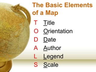
1.
The Basic Elements of
a Map T Title O Orientation D Date A Author L Legend S Scale
2.
Directions • Cardinal: • Intercardinal
(Intermediate): • Secondary Intercardinal:
3.
4.
5.
Scale • Graphic: • Bar
Scale: • Ratio:
6.
1” = 25
miles
7.
8.
1:250,000
Descargar ahora